WASHINGTON — Forecasters are gearing up for what could be a busy hurricane season. While the official forecast from the National Oceanic and Atmospheric Association won't be released until May 23, early indications are that the atmosphere will be primed for above-average activity.
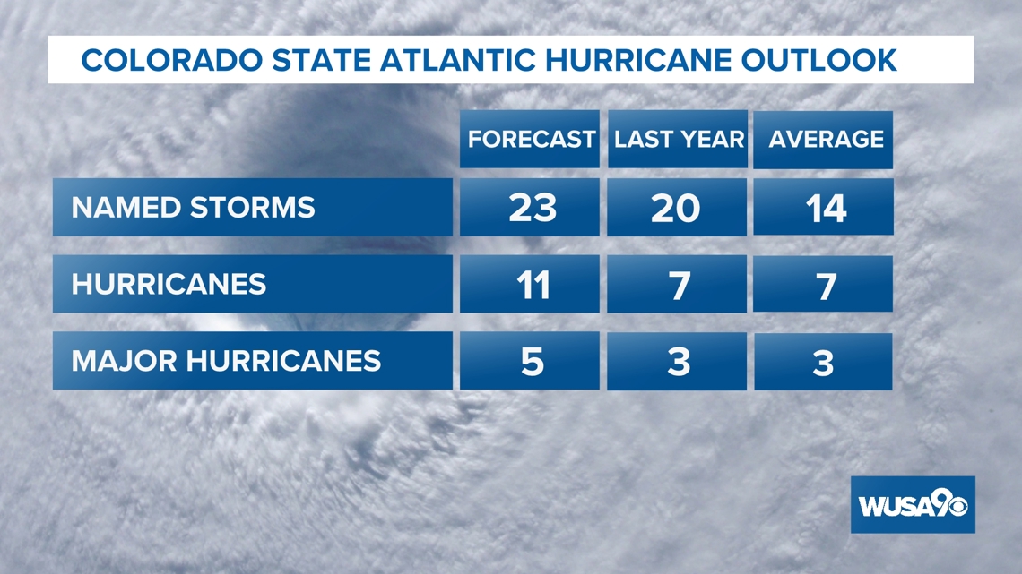
Colorado State University tropical meteorology experts are calling for an "extremely active" season. CSU is calling for 23 named storms, 11 hurricanes, and five major hurricanes. A major hurricane is classified as Category 3 and above. On average, the Atlantic basin sees 14 named storms, seven hurricanes, and three major hurricanes.
Why so busy?
The short answer: Very warm water and a potential lack of wind sheer. Hurricanes love warm water. It helps to provide energy for the storm. Water temperatures of about 80 degrees is what it takes to get hurricanes and tropical systems going. The current (surface) ocean temperatures are above average for spring and that trend is expected to last into the summer.
"A very warm Atlantic favors an above-average season, since a hurricane’s fuel source is warm ocean water. In addition, a warm Atlantic leads to lower atmospheric pressure and a more unstable atmosphere. Both conditions favor hurricanes," experts at CSU wrote.


Wind sheer is a change in wind speed or direction with height. Imagine someone wildly flapping their arms around as a figurative example of wind sheer. Newsflash: hurricanes don't like wind sheer. It disrupts their ability to form.
By the time we get to peak hurricane season — typically August, September and October — there may not be much wind sheer around.
We are forecasted to be in a La Nina weather pattern, which favors higher hurricane activity due to the lack of wind sheer.
Will all of the predicted storms make landfall?
Not all of the named storms will make landfall. Some will stay at sea and not make landfall, but could send big waves ashore.
What does this mean for me?
If you live along the coasts or even here in the Mid-Atlantic where the remnants of storms often pass, just be prepared to protect yourself and your property. This means if you hear of any type of tropical storm or hurricane watch or warning, have a plan to either evacuate or safely ride out the storm if it's possible.
What about climate change?
Research suggest that climate isn't necessarily causing more hurricanes, but rather stronger hurricanes. Research from the Geophysical Fluid Dynamics Laboratory, a division of NOAA, found that hurricanes may produce higher rainfall rates. More rain, means more intense flooding. Expert analysis found that with sea level rise, storm surge could be more intense. We could also see more intense hurricanes, those of category 3 and above.
Do you have a news tip on this story or any other story? We want to hear from you. Tell us about it by emailing newstips@wusa9.com.
MORE WAYS TO GET WUSA9
DOWNLOAD THE WUSA9 APP
Apple App Store: WUSA9 News on Apple
Google Play Store: WUSA9 News on Android
HOW TO ADD THE FREE WUSA9+ APP TO YOUR STREAMING DEVICE
ROKU: add the channel from the ROKU store or by searching for WUSA9.
For both Apple TV and Fire TV, search for "WUSA9" to find the free app to add to your account. Another option for Fire TV is to have the app delivered directly to your Fire TV through Amazon.
SIGN UP TO RECEIVE WUSA9 NEWSLETTER
Subscribe to our daily WUSA9 Newsletter for top stories from WUSA9 curated daily just for you. Get content and information right now for can’t-miss stories, Commanders content, weather, and more delivered right to your inbox.

