The DC Metro area took a solid hit from freezing rain overnight and early this morning. If you were watching WUSA9 this morning, you heard my colleague Howard Bernstein and I talk about the reason that freezing rain sometimes happens-- cold air is near the surface, but it's milder aloft. Let's look at this concept a little more in-depth, using the forecast tools that we meteorologists use!
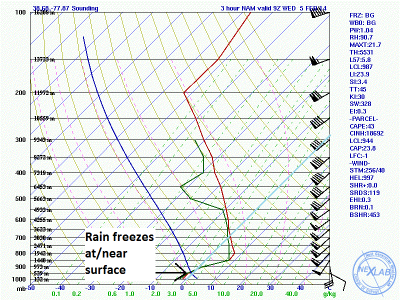
When forecast wintry precipitation type, it's very helpful to look at a Skew-T, log P diagram. This is short for "skewed temperature, logarithmic pressure" (I won't get into the reasoning for this type of diagram today!) The purpose of this diagram is to show us how the temperature, wind, and humidity change through a vertical cross-section of the atmosphere. It shows us not just the surface temperature, but the temperatures above the surface. Notice the diagonal lines from the bottom left to the top right of the diagrams. These are the skewed temperature lines. In each of the three graphics to follow, I highlighted the 0ºC isotherm (freezing temperature line) in light blue.
The red and green lines represent temperature and dewpoint, respectively. When the red and green lines are basically on top of each other, you can be assured that cloud cover is in place, and it's likely that precipitation is falling, too. This is easy to see in the first diagram. The temperature and dewpoint lines are not only on top of each other, indicating thick clouds, but the temperature line never crosses over that 0ºC isotherm. The snow that originates in the clouds is able to fall all the way to the surface as snow.
In the second diagram, the temperature and dewpoint lines cross over to the right of the 0ºC isotherm. This means that, in that part of the atmosphere, the temperature rises above the freezing point, which allows the snow in the cloud to melt into raindrops. But then, notice that the red and green lines cross back over to the left of the freezing point. This means that the temperature is back below the freezing point. In this diagram, we can see that the point of freezing is 1,428 meters above sea level, and the temperature remains below freezing all the way to the surface. The raindrops freeze before they reach the surface because the cold air is deep enough to cause the freezing process to happen as the raindrops are falling. Have you figured out what type of precipitation this is? It's sleet!
Finally, we have the type of precipitation that was widespread today... freezing rain. Again, you can see that the temperature and dewpoint lines cross over the 0ºC isotherm, indicating that the snow has melted. But in this scenario, the warm layer (above freezing) is deeper, and the cold layer (below freezing) is shallower. The rain doesn't have time to freeze before reaching the ground. Instead, it coats all the surfaces that are below the freezing point, which is why we had ice on all the tree branches, bushes, grasses, and any untreated sidewalks.
The next time we have a "mixed bag" of wintry weather in the forecast, maybe you'll take a look at the forecast skew-T diagrams, and you can make your own prediction as to what type of precipitation we'll get!