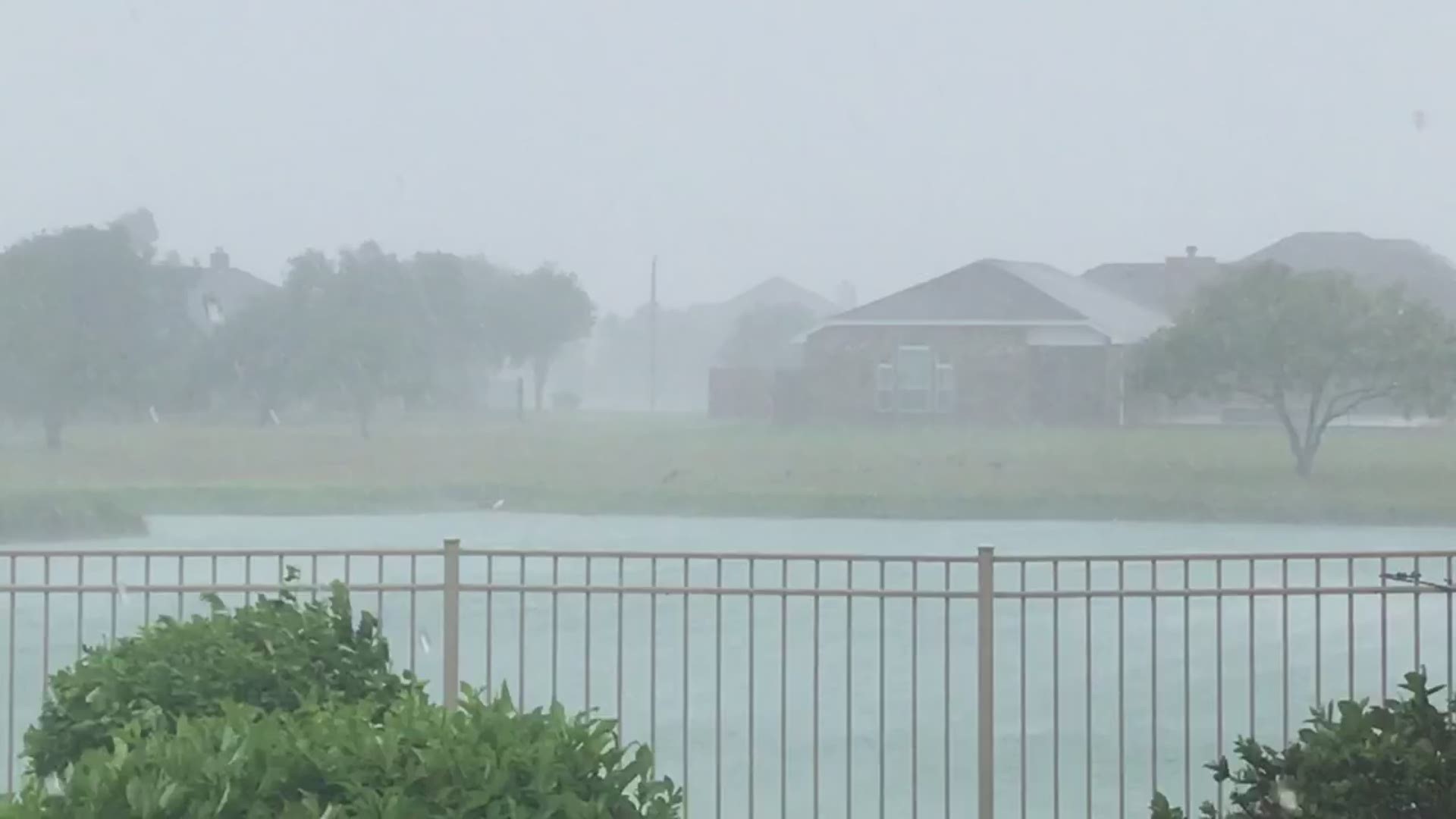
UPDATE 11:41 AM:
The Oso Creek flooding warning has been cancelled with a lower forecast crest today (Last night it was up over flood stage).
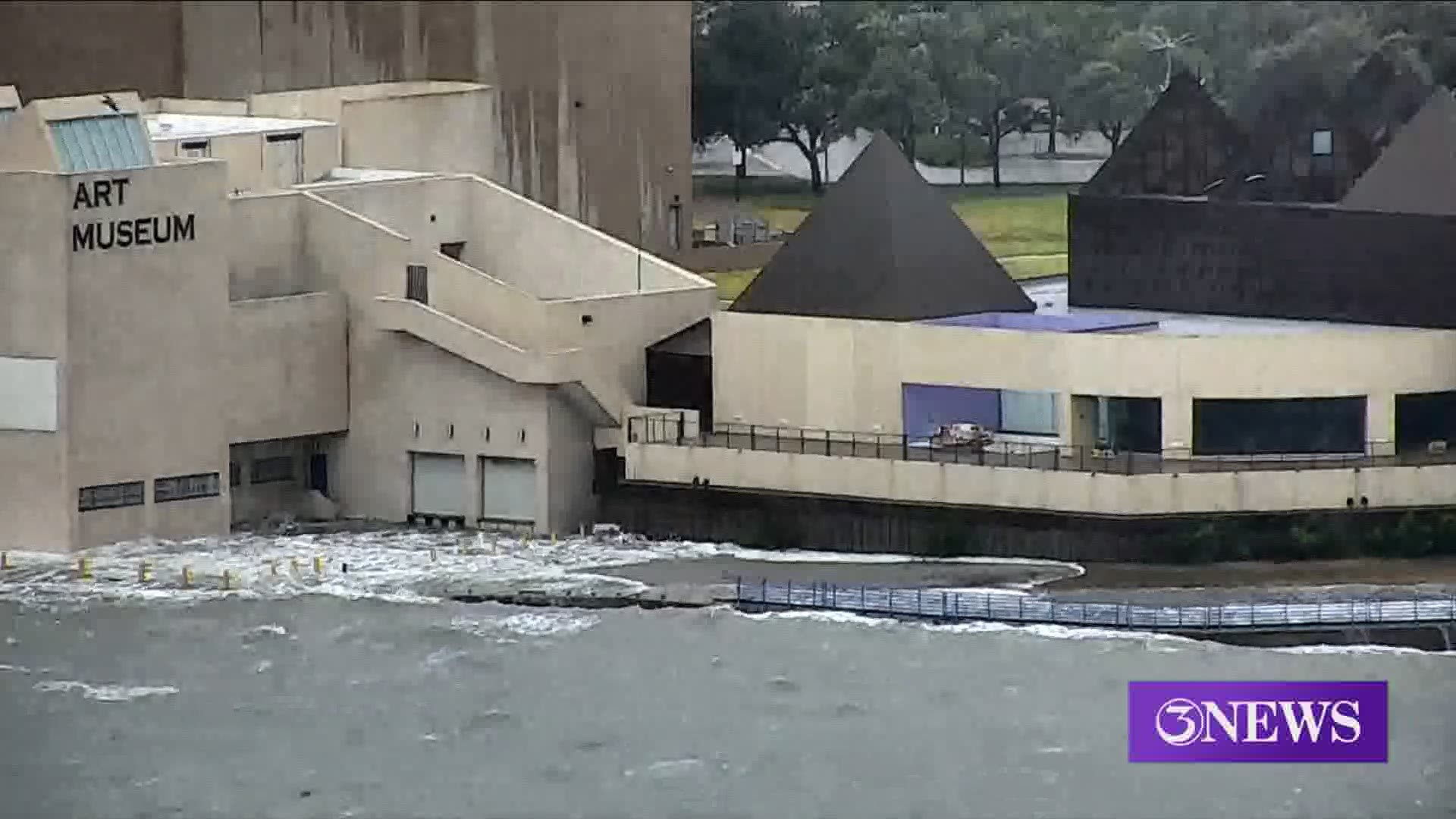
Also, the waters near the Texas State Aquarium and Art Museum of South Texas on either side of the port have receded. Interesting to note here...The tide was only 3-4 ft. above normal at this location. Not much of a rise for such a dramatic affect.
UPDATE 10:46 AM:
Tornado Warning in effect until 11 AM. This includes San Diego, TX extending into Rosita, TX.
UPDATE 10AM
Center of Tropical Storm Hanna moving west-southwest near 9 MPH. Motion is expected through Monday. Will move over northeastern Mexico tonight.
Maximum sustained winds down to 45 MPH. It has weakened immensely since landfall. This will soon become a Tropical Depression by the afternoon/evening over Mexico.
UPDATE 9AM
Tornado Warning including Charco, TX until 9:30 AM. Also, penny size hail possible within this particular storm. This is northeast of Corpus Christi.
UPDATE 8:12PM
Here’s a look at what kind of wind speeds we had yesterday. Baffin Bay reported a wind speed of 81 MPH closer to the center of the hurricane. Incredible!
Source: National Weather Service
UPDATE 7:24AM
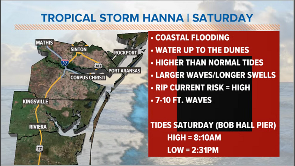
In addition, Coastal Flood Warnings in effect. Numerous roads will be closed, beach roads impassable and low lying property will be inundated.
UPDATE 7AM
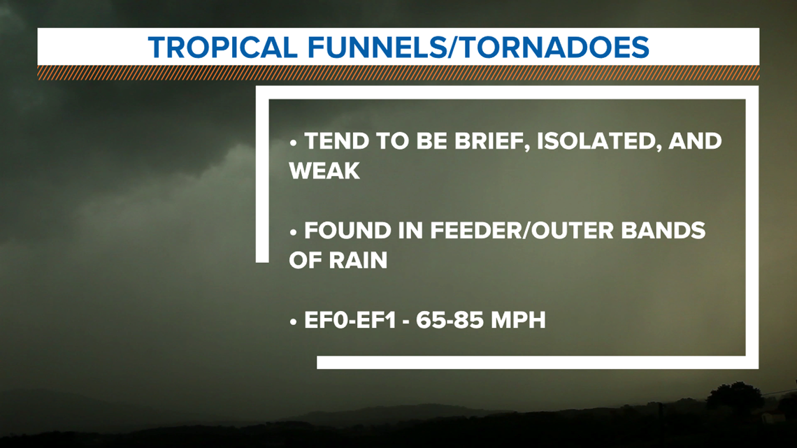
As the outer tropical bands continue to spiral into the area, they have the possiblity of spinning up a tornado. This is just a watch. We're watching out because conditions are favorable for isolated activity. Nothing as of right now.
This has been recently updated. It expires at 10 PM tonight. (7:50 AM Update)
UPDATE 6AM
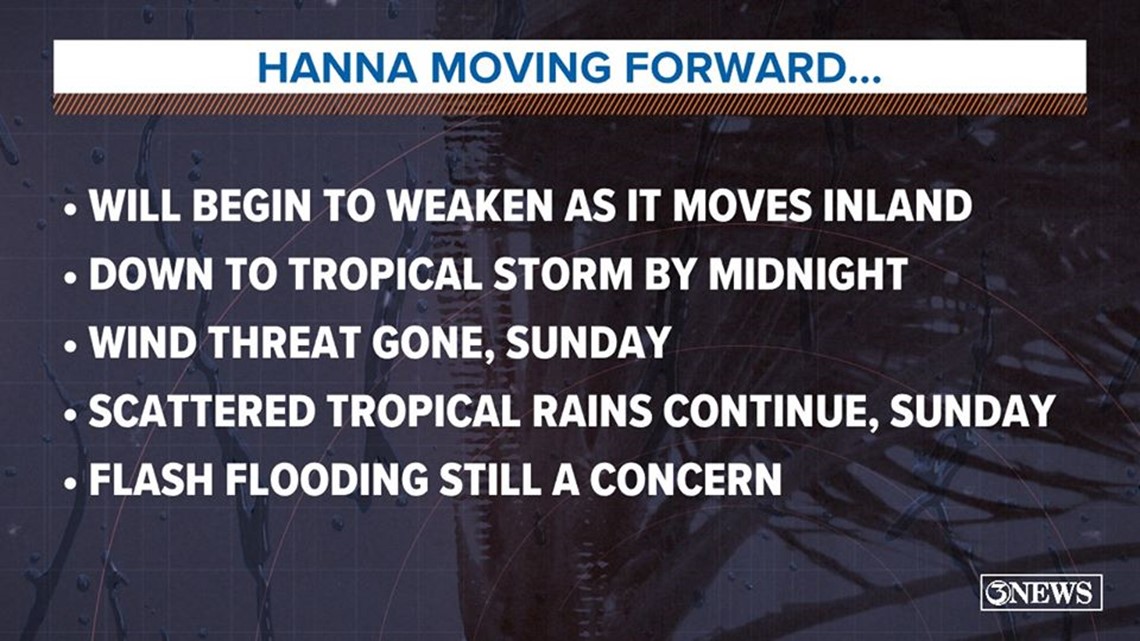
Hanna is now a weakening Tropical Storm crossing the Mexico border after moving into Starr county. This will dive into Mexico falling apart through Monday. This will continue to send in waves of tropical rain through the day today leading to potential flooding.
UPDATE 4 a.m.
- Storm surge warnings were discontinued along the Texas coast. (however, some flooding is still possible).
- Tropical Storm Warning discontinued north of Baffin Bay (so no tropical storm force winds. Still breezy and even gusty but not dangerous)
- Hanna is now a Tropical Storm. Winds sustained 60 MPH.
- Moving West Southwest bear 9 MPH.
- Will continue to weaken as it moves into Mexico through tonight.
UPDATE 2:20 a.m.
Hanna is currently a tropical storm pushing over the western Rio Grande Valley.

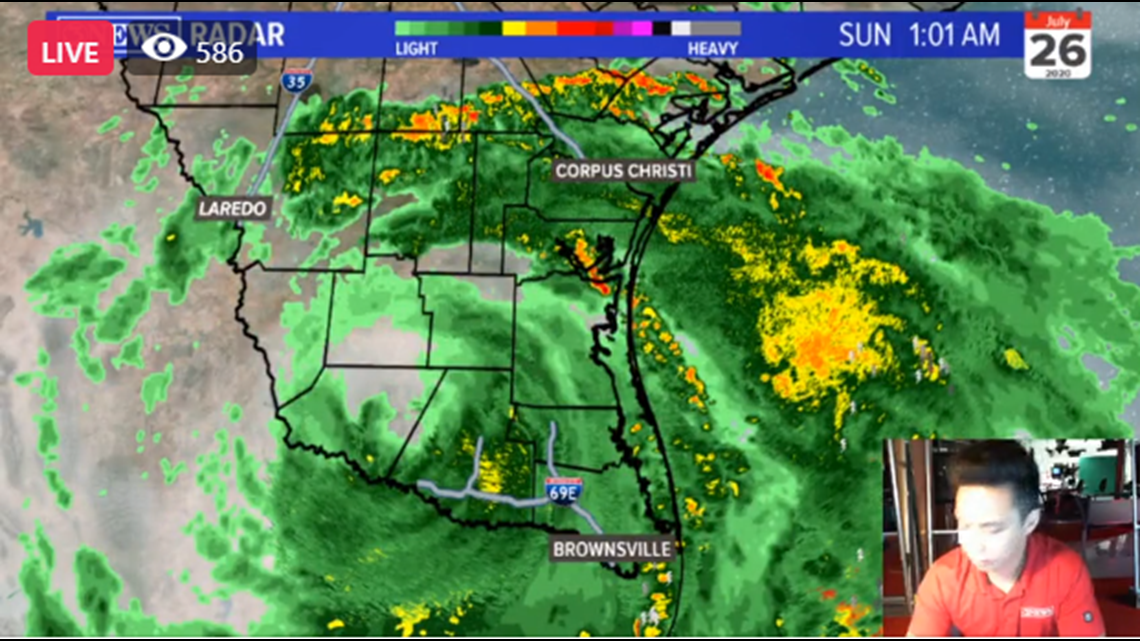
- Corpus Christi office of emergency management officials said a storm surge is in effect through Sunday. South of Port Aransas could have two to four more feet. A Coastal flood advisory is also in effect with one to two feet inudation north of Port Aransas.
UPDATE 11:08 p.m.

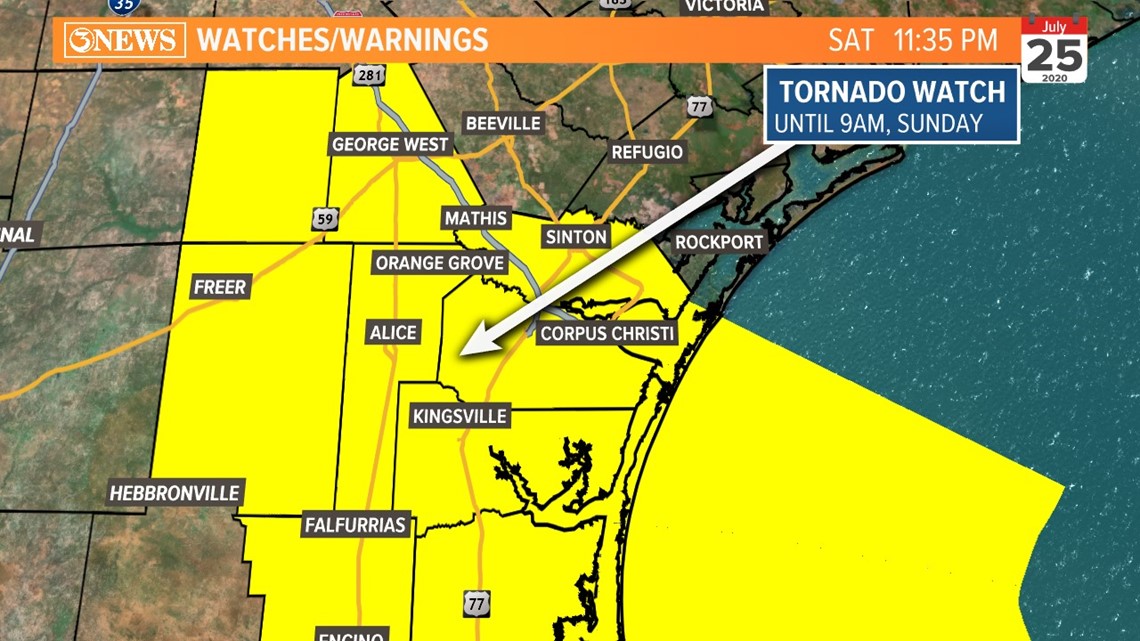
- A tornado watch was issued for Jim Wells, San Patricio, Nueces, Kleberg and all counties south of Kleberg until 9 a.m.
UPDATE 10:47 p.m.
- A Tornado warning was issued for Jim Wells County until 11:42 p.m.
UPDATE 10:16 p.m.
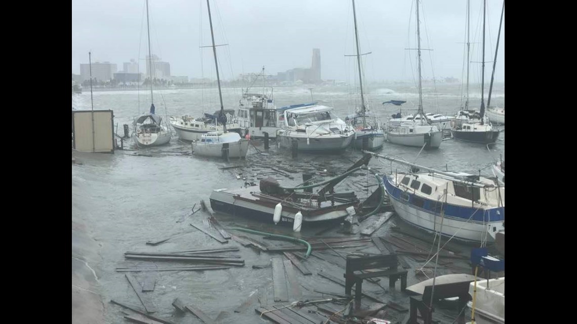
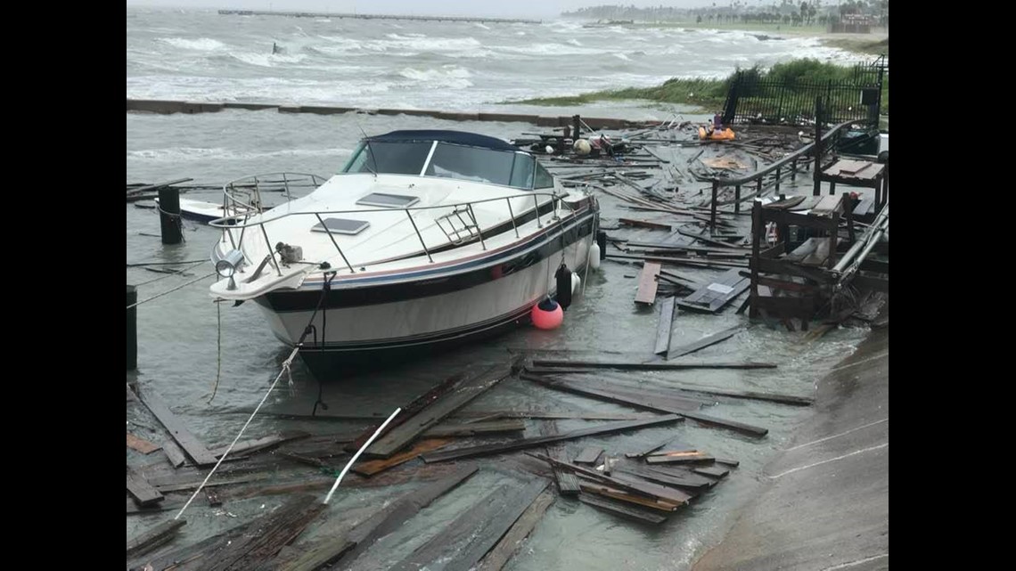
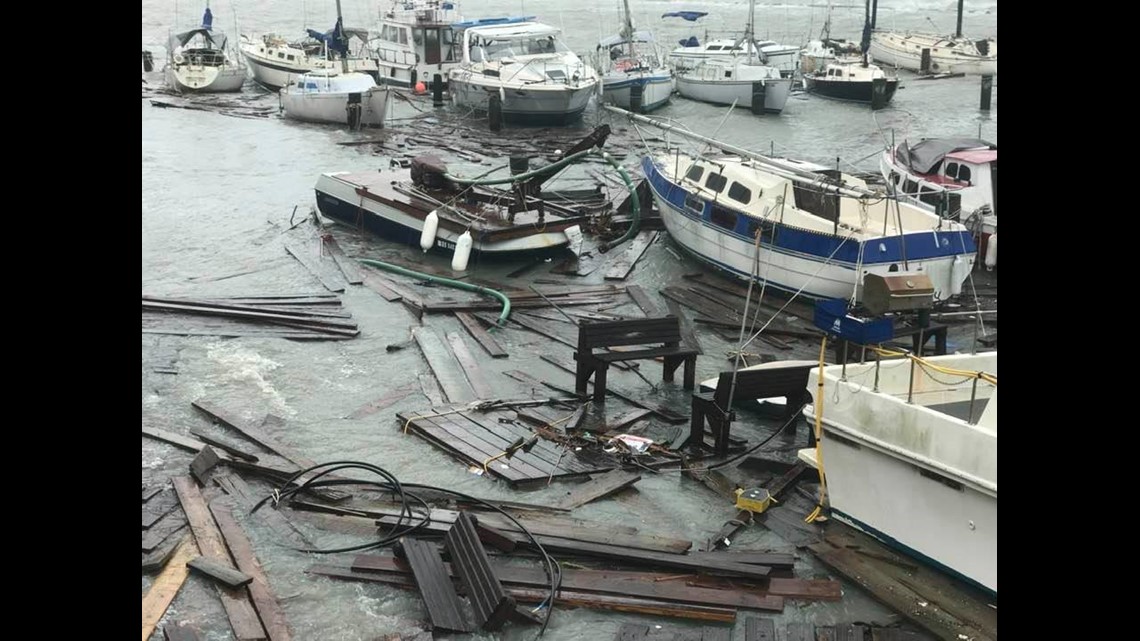
- The couple aboard a house boat, originally wanting to stay and ride out the storm, at the Marina Del Sol Marina was rescued by the Coast Guard.
- A tornado warning was issued for San Patricio County until 10:57 p.m. areas also affected are Lake Corpus Christi and Lakeside.

UPDATE: 9:44 p.m.
- Nueces County was downgraded from a Hurricane warning to a tropical storm warning
UPDATE: 9:13 p.m.
- A tornado warning has been issued for San Patricio, Jim Wells, Bee and Aransas counties until 9:55 p.m.
UPDATE: 8:37 p.m.

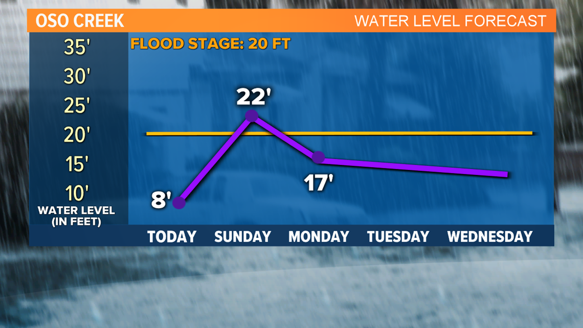
- Oso Creek under flood warning starting Sunday morning and is expected to flood up to 22 inches.
UPDATE: 8:30 p.m.
- Corpus Christi Fire Chief Robert Rocha confirms crews responded to Marina Del Sol Marina on Ocean Drive to rescue a couple from their houseboat. Rocha said the couple decided to stay on their boat and wait out the storm.
UPDATE 7:58 p.m.
- A Tornado warning has been issued for San Patricio County near Gregory Portland until 8:39 p.m. Shelter in place, avoid windows, don't travel and avoid flying debris.
Photos/video of damage at Marina Del Sol Marina on Ocean Drive in Corpus Christi. Not associated with the Marina Del Sol Condominiums. Emergency crews attempting to rescue a couple from their house boat.



UPDATE: 7:28 p.m.
- Tornado warning issued for Jim Wells and Kleberg Counties until 8:24 p.m.
UPDATE 7:09 p.m.
- Tornado warning issued for Nueces and Kleberg Counties until 7:45 p.m.
UPDATE 6:15 p.m.
- Hurricane Hanna has made a second landfall in Kenedy County.
UPDATE: 5:40 p.m.

Most of North Beach underwater. Water looks to be flooding the first floor of the Art Museum downtown:
UPDATE: 5:02 p.m.
- Hurricane Hanna makes landfall on Padre Island, TX, as a Category 1 Hurricane - 90 mph winds.
UPDATE: 4 p.m.
- Moving west-southwest near 8 MPH.
- Strong Category 1 Hurricane with 90 MPH winds with gusts up to 115, closer to the eye of Hanna.
- Storm surge 3-5 FT has been observed. Areas near Bob Hall flooding with water moving onshore advancing over the parking lot.
- Rapid weakening as Hanna moves inland.
UPDATE: 3 p.m.
- 85 MPH sustained winds with higher gusts around the eyewall of Hanna.
- Winds will continue to stay near Tropical Storm force here in Corpus Christi.
- Hanna will drive west into Kenedy county this afternoon.
- The eye is not too far offshore.
- Landfall is expected within the next few hours.
- Flash flood watch continues until 7 p.m.
- Storm surge 4-6 FT between Port Aransas and Baffin Bay.
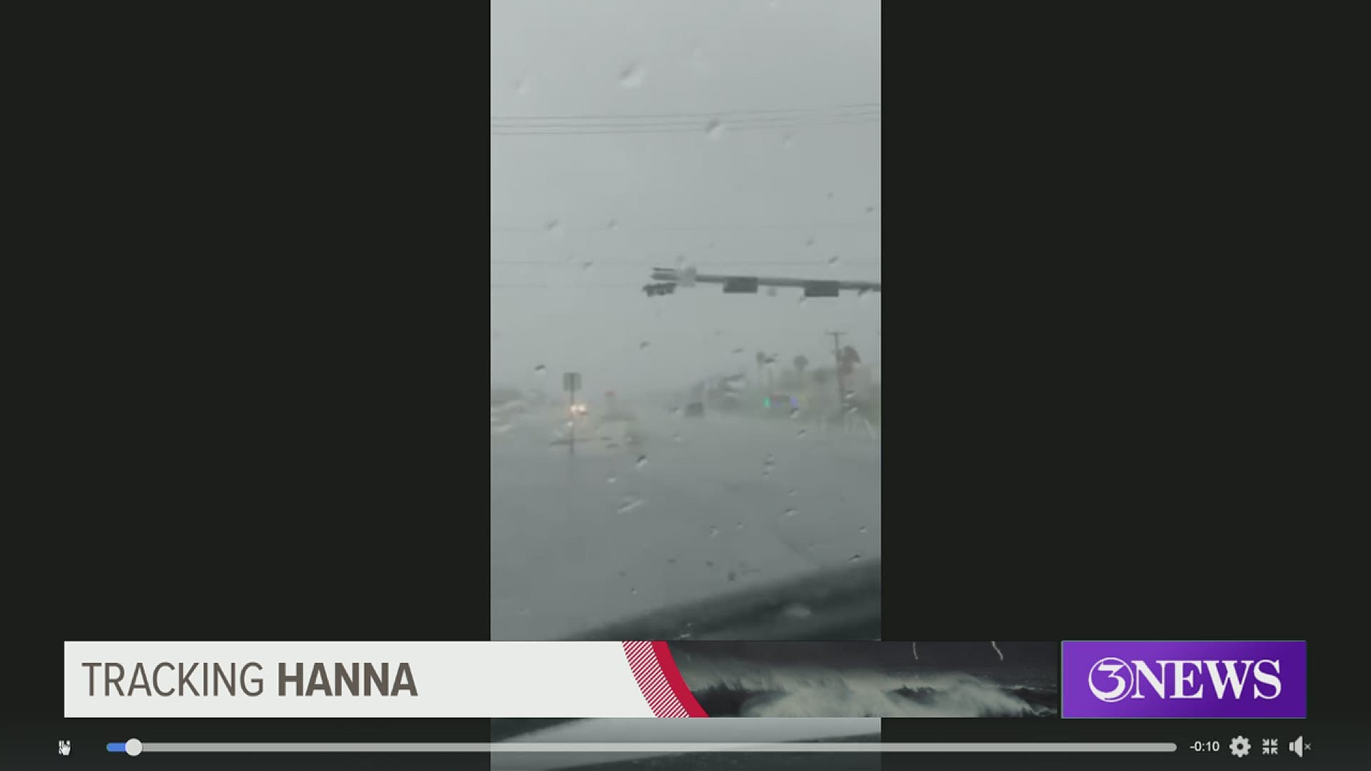
Traffic signal nearly hits pickup truck on South Padre Island Drive:
UPDATE: 1:30 p.m.
- Hanna will move into Kenedy County this afternoon, then into Mexico Sunday, weakening to a tropical depression.
- Numerous downpours for the remainder of Saturday, then scattered tropical showers Sunday in the Coastal Bend.
UPDATE: 1 p.m.
- While the National Hurricane Center is calling for a landfall closer to 7 PM, the center of Hanna is about 30 miles offshore.
- It's closing in on Kenedy County meaning if it continues at its pace, this would be an afternoon landfall.
- Not a whole lot of change in the stats/track on Hanna. Still in line to move in to Kenedy County this afternoon as a category 1 hurricane.
- Tornado Warning no longer in effect.
- Power outages are currently affecting over 14,000 customers with more than 289 outage cases as winds begin to pick up. To report a power outage click here.
- Drivers should approach street intersections with caution by slowing down and treating intersections as 4-way stops until power is restored.
Hurricane Hanna wind and rain bands:
UPDATE: 12:30 p.m.
- Ferry service has been temporarily suspended.
- As of 12:45 p.m., there are around 10,000 customers without power.
- Storm surge has been raised for 4-6 ft from sea level.
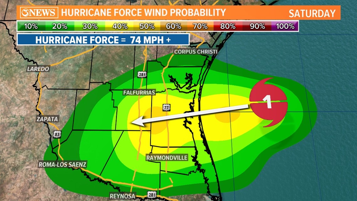
- This chart shows the chance for hurricane force winds (74mph+).
- 10% chance in Corpus Christi, 20% chance in Kingsville.
- Highest probability (40-50%) in Kenedy County and parts of Brooks County.
- Hurricane Hanna is at 80 MPH winds with 100 MPH wind gusts.
- Landfall expected at 7 p.m. between Baffin Bay and Port Mansfield.
- Maximum sustained winds have increased to 80 MPH with higher winds gusts to 100 MPH near the center.

UPDATE: 11:30 a.m.
- Hurricane Hanna continues to track west, waiting for it to take its southwesterly turn.
- Keeping close watch on how the rain around the eye moves; that's where the strongest winds in the storm will be located as the storm makes landfall in Kenedy County.
- National Hurricane Center updated forecast cone puts landfall around 7 PM tonight near Kenedy county.
- This will keep storm surge potential high in Corpus Christi.
- Tropical bands will continue to wrap around and drop heavy rainfall through tomorrow.
UPDATE 10 a.m.
- Hurricane Hanna has strengthened sustained winds speeds offshore.
- Sustained winds 80 MPH with 100 MPH wind gusts closer to the center.
- Hurricane force winds extend outward up to 25 miles from center.
- Tropical Storm force winds will extend 90 miles outside center.
- Storm surge between 3-5 FT including Corpus Christi Bay. Copano Bay and Aransas Bay .
- Kleberg County Judge Madrid activates the FEMA dome as a safe room for residents to ride out the storm in their area. The dome is scheduled to open at 10 a.m. and is located behind the H.M. King High School at 2210 Brahma Blvd, Kingsville, Texas.
UPDATE 7 a.m.
- Hanna moving west at about 9 MPH. This motion will continue through the morning. A gradual turn to the west-southwest is expected.
- Maximum sustained winds at 75 MPH with higher gusts indicating a Category 1.
- Additional strengthening expected.
- Port Mansfield to Baffin Bay Storm Surge: 2-4 FT
- Hurricane Force Winds extend 25 miles out of the center.
UPDATE: 4 a.m
- Hanna moving west at 9 MPH. This motion will continue through the morning. A gradual turn to the west-southwest is expected.
- Maximum sustained winds have INCREASED to near 70 MPH. This is just below hurricane strength. Additional strengthening is expected before it makes landfall this afternoon/evening.
- Forecast Cone continues to drift a little farther south. Landfall will be between southern Nueces county and as far south as Willacy county. Closer to the Rio Grande Valley.
- Mouth of the Rio Grande Valley to Port Mansfield: 1-3 FT STORM SURGE
- Port Mansfield to Baffin Bay: 2-4 FT STORM SURGE
- Hurricane force winds extend 20-30 miles from center of storm. Tropical Storm Force winds extend outward up to 90 miles from the center.
UPDATE: 10 p.m.
- Hanna is looking more and more impressive on satellite imagery and now the winds are catching up with its satellite presentation.
- Significant increase in sustained winds in Tropical Storm Hanna, thanks to a drop in pressure. Now sustained at 65 mph - gusts up to 75 mph. Hanna is moving west at 8 mph, 165 miles east of Corpus Christi.
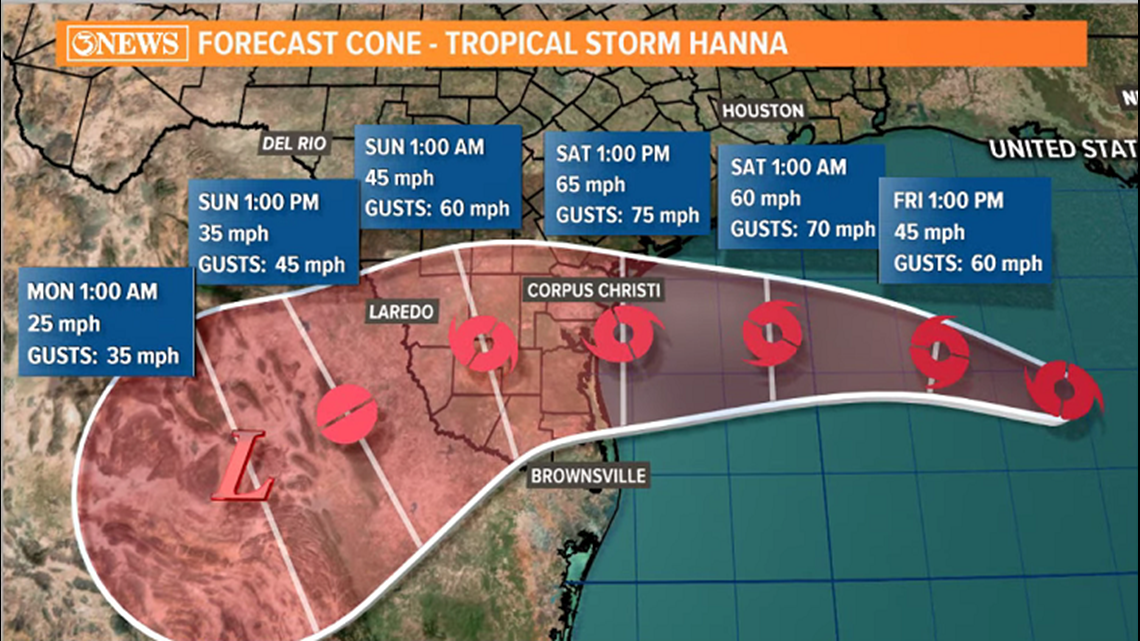
- 10 p.m. forecast cone has similar trends that we've seen through the duration of the evolution of this storm. Namely, a slight southward shift in the forecast cone. Corpus Christi is actually outside the cone, but impacts will still be felt in Corpus Christi and other locations outside of the cone.
- Now forecast to make landfall south of Baffin Bay on Saturday afternoon.
- Winds are forecast to be sustained near hurricane force near the center of the storm, gusting to 85 or 90 mph.
- Strongest winds will be nearest the storm center.
- At this point, category 1 hurricane status at landfall is likely. Remember, tropical storm force conditions will extend well away from center and outside of the forecast cone.
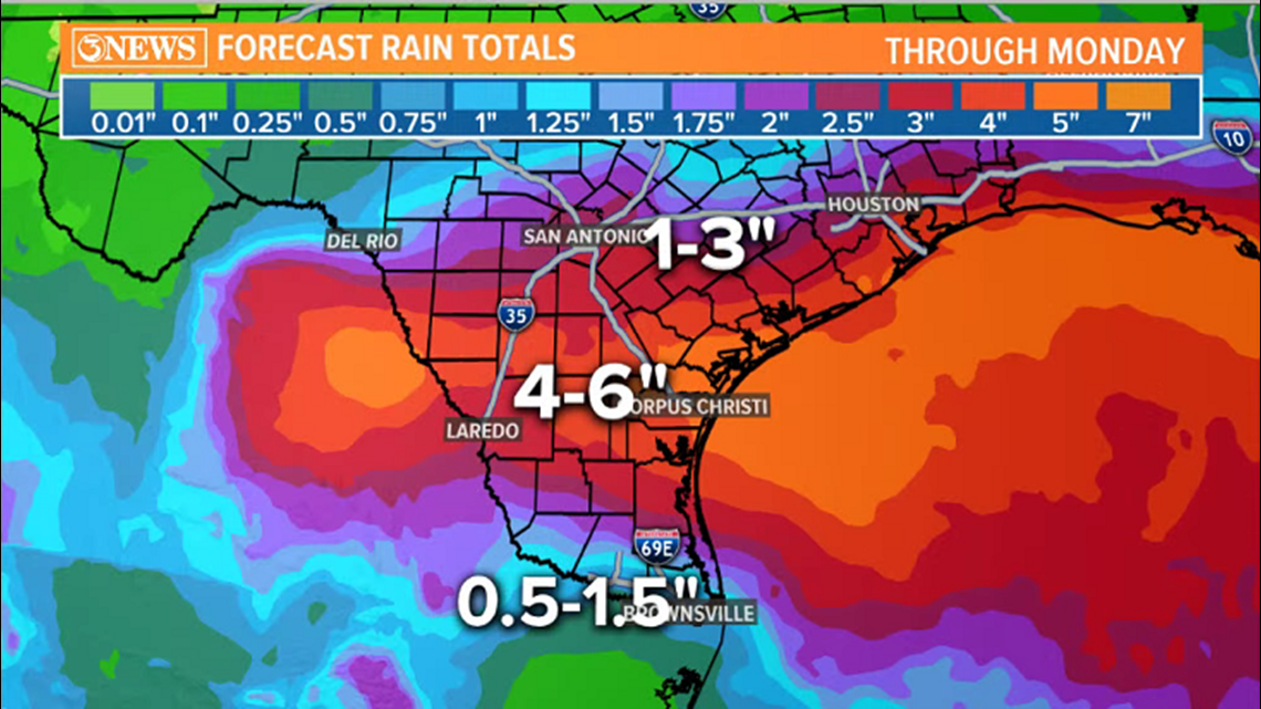
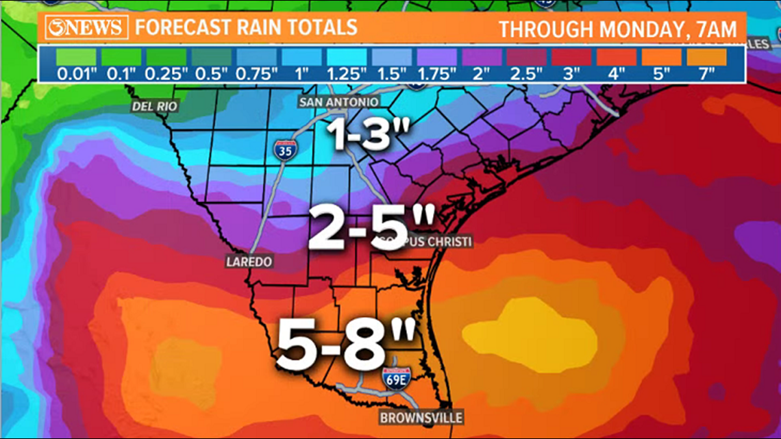
- Heavy, flooding rains will also be problematic. Highest accumulations expected in the Valley. Between 3 and 6" in the Coastal Bend, with locally higher amounts through Monday.
UPDATE: 9:20 p.m.
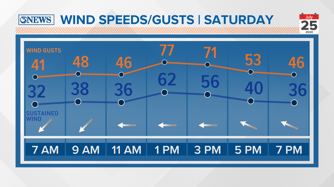
- This is an idea of how winds may look like in Corpus Christi Saturday as Hanna moves in.
- Tropical storm force is as early as 8 a.m., steadily increasing through noon.
- The early afternoon will be the most intense with sustained winds between 60-70 mph and wind gusts of category 1 hurricane force. Wind speeds decreasing after sunset. This would cause power outages if it verified.

Facebook Live Q&A with Bill Vessey: 8:45 p.m.
UPDATE: 7 p.m.
- Tropical Storm Hanna is still at 50 mph sustained winds, gusts to 65 mph. It's moving west at 10 mph, less than 200 miles away from Corpus Christi.
- The National Hurricane Center's latest forecast cone does bring Hanna to hurricane force just before landfall Saturday afternoon. Wind gusts of up to 90 mph is notable.
- I (Alan Holt) will admit that this surprises me, given most model guidance does not support this, but it is possible that this storm can strengthen as there is no wind shear, cool water, or lack of moisture impeding the progression.
- It now has less than 24 hours to intensify. Remember, rapid intensification is when a storm increases its wind speeds by 35 mph in 24 hours time, per the National Hurricane Center.
- Forecast track has remained fairly consistent center aimed at Baffin Bay, south of Corpus Christi, making landfall Saturday afternoon. Tropical storm force conditions as early as 8 a.m. along the Texas Gulf Coast.
From the National Weather Service:
- The storm is continuing to move towards the Texas coast
- Hurricane, Storm Surge and Tropical Storm Warnings remain in effect
- Flash Flood Watch in effect. 5-10" of rain w/ isolated amount to 15" possible.
UPDATE: 5:30 p.m.
On Boarding Up:
- It's a personal choice. We know that the threshold on windows holding against wind is ~80mph. This storm is now forecast to reach Hurricane status (75mph winds) with 85 mph gusts. The strongest winds are going to be near the center of the storm, which - as of now (5 p.m. Friday) - is forecast to be near the Baffin Bay.
- The locations most prone to the strongest winds will be spots close to the center of the storm and nearest the coast. Strongly consider boarding up in these locations:
- The Island
- South Side of Corpus Christi
- Flour Bluff
- Southern Nueces County
- Eastern Kleberg County
UPDATE: 4 p.m.
Hanna continues to drive west-northwest as a moderate Tropical Storm. However, based on recent satellite imagery, it's in the process of forming an eyewall. This will aid in strengthening through tomorrow morning. The National Hurricane Center is calling for a Category 1 just before landfall Saturday afternoon.
- Tropical Storm Hanna strengthening to a Category 1 Hurricane by landfall midday tomorrow near Baffin Bay.
The 3News Weather Team and National Hurricane Center are following the very latest on Tropical Storm Hanna as it moves through the Gulf of Mexico towards the Texas coast.
Below are the latest updates on the storm.
UPDATE: 2 p.m.
UPDATE: 1 p.m.
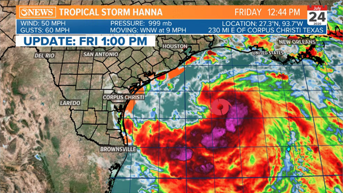
Winds have increased to 50 mph, with gusts of 60 mph in Tropical Storm Hanna. Strengthening is expected through landfall, Saturday afternoon. Current forecast has Hanna making landfall along the South Texas Gulf Coast early Saturday afternoon. Winds at 65 mph with gusts of 75 mph.

UPDATE: 10:30 a.m.
Tropical Storm Hanna has strengthened a little this morning. Sustained winds of 45 mph, up from 40 mph last night/this morning. The forecast track at 10am has not changed a whole lot; just a slight jog to the South, but still in line to move in Saturday afternoon along the South Texas Gulf Coast. Intensity forecast still calls for a 65mph tropical storm with gusts up to 75 mph. Highest winds will be confined to near the center of the storm. If I had to pick a spot for landfall of the center of this storm it would be in the Baffin Bay area. Remember, tropical storm force conditions can and will likely extend 50 miles or so away from the center of the storm.
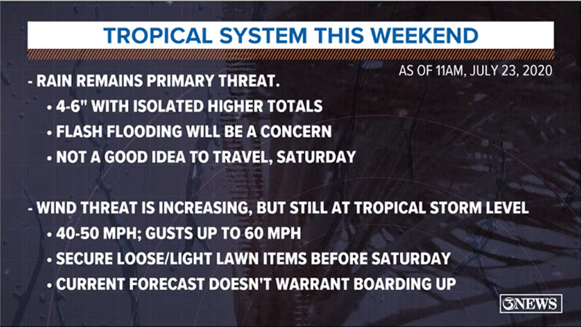
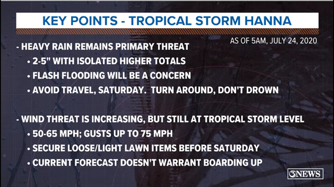
At this point, I do not think winds are forecast to be high enough to warrant boarding of windows. That being said, they will be strong enough to blow loose items around, so SECURE THOSE TODAY.

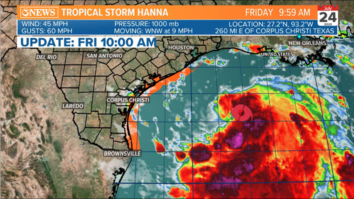

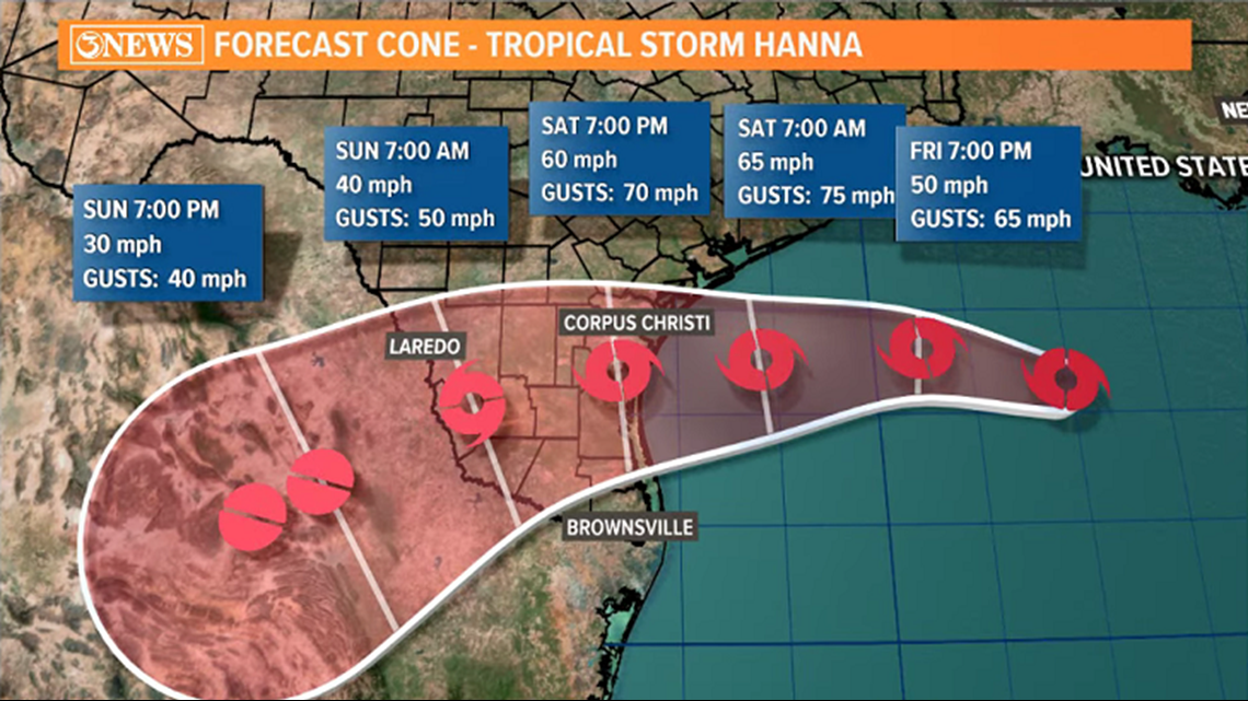

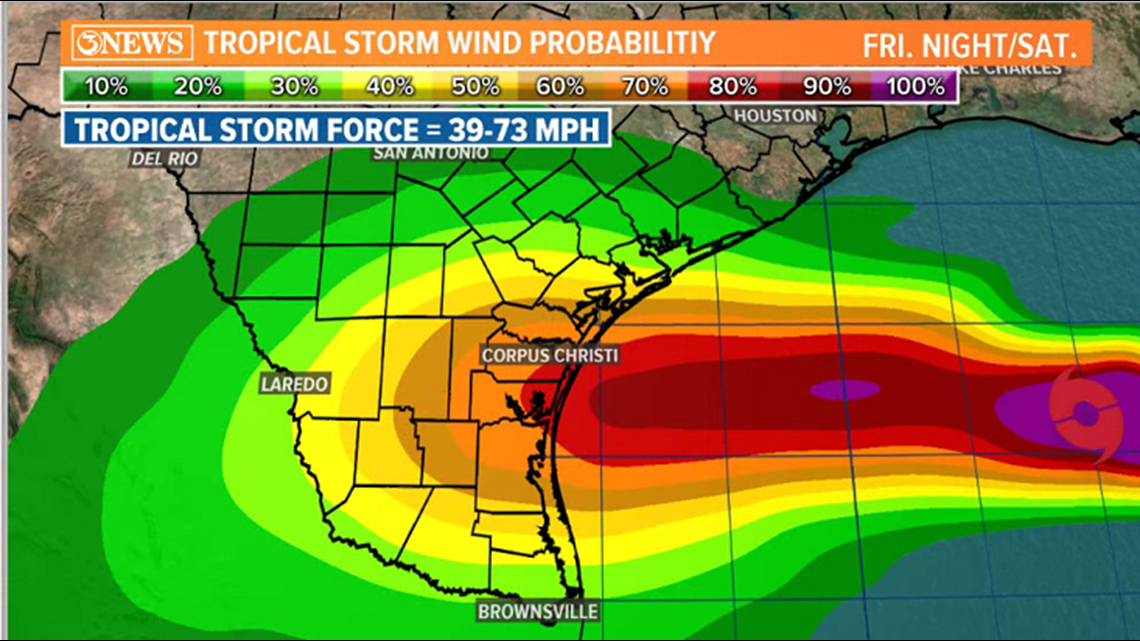

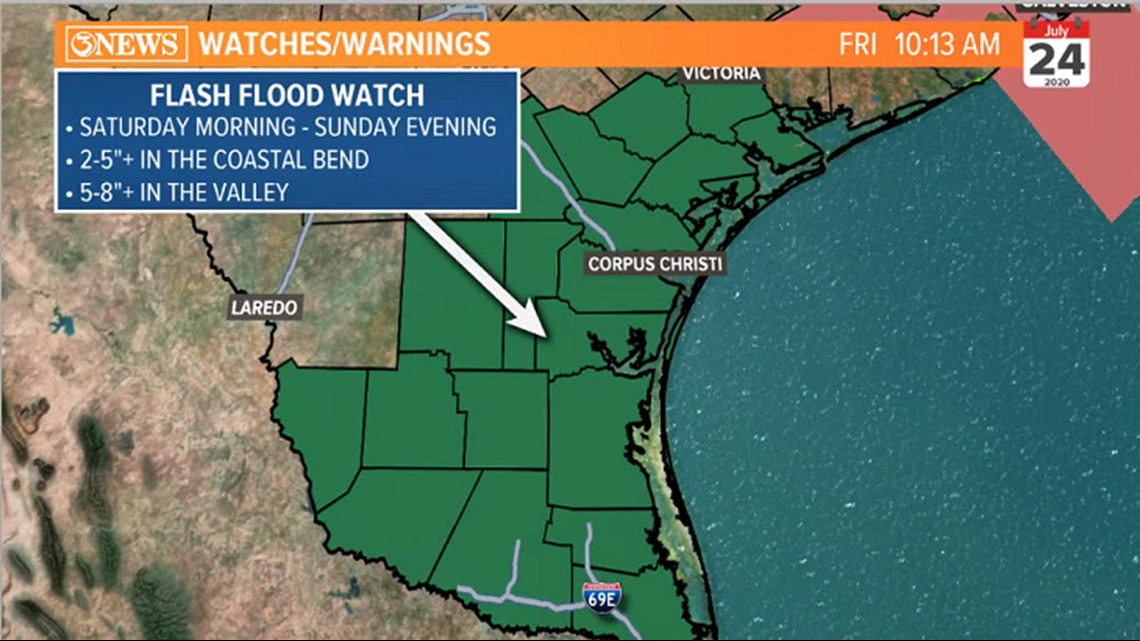
Flash Flood Watches will be in effect all weekend as flooding rains are expected throughout all of South Texas. Heaviest rains and highest totals will be focused in deep South Texas in the valley.

UPDATE: 8:55 a.m. -- Live Question and Answer Session:
A pair of upper level lows flanking Hanna to the East and SW are aiding in outflow (exhaust) of the storm, which should warrant a strengthening storm plus hurricane hunters finding stronger winds.
Been getting questions on why this is trending south. In my opinion, the upper level low to the SW of Hanna is tugging the storm to the south but that ULL is moving away and weakening a little.
There's some wind shear in the northern gulf which is affecting some of the northern flank of the storm.
Overall, I'd expect the 10 a.m. update to indicate a stronger tropical storm. We'll see.
UPDATE: 7:30 a.m.
Given the current forecast of Tropical Storm Hanna bringing tropical storm force conditions to South Texas (39-73 mph winds), there will probably be some power outages in the region, Saturday. Keep in mind, sometimes power gets knocked out on breezy/sunny days (30-40 mph winds)
Coastal Effects and Key takeaways from Tropical Storm Hanna, Saturday.


UPDATE: 4 a.m.



UPDATE: July 23 9:58 p.m.
- Tropical Storm Hanna officially forms. Hurricane Hunters found stronger winds and a more defined circulation in the last recon mission.
- This still has another day left over the western Gulf of Mexico. Plenty of time to continue to strengthen.
UPDATE: 7 p.m.
- Maximum sustained winds are still at 35 mph with higher gusts. Tighter circulation expected to undergo strengthening through tomorrow. 410 mi ESE of Corpus Christi. Hurricane hunter plane is currently investigating.
- Tropical Depression 8 continues to track closer to the South Texas coast. The storm has been getting better organized and is expected to become Tropical Storm Hanna before landfall. We're tracking the very latest on the storm from the 3News Weather Team and the National Hurricane Service.

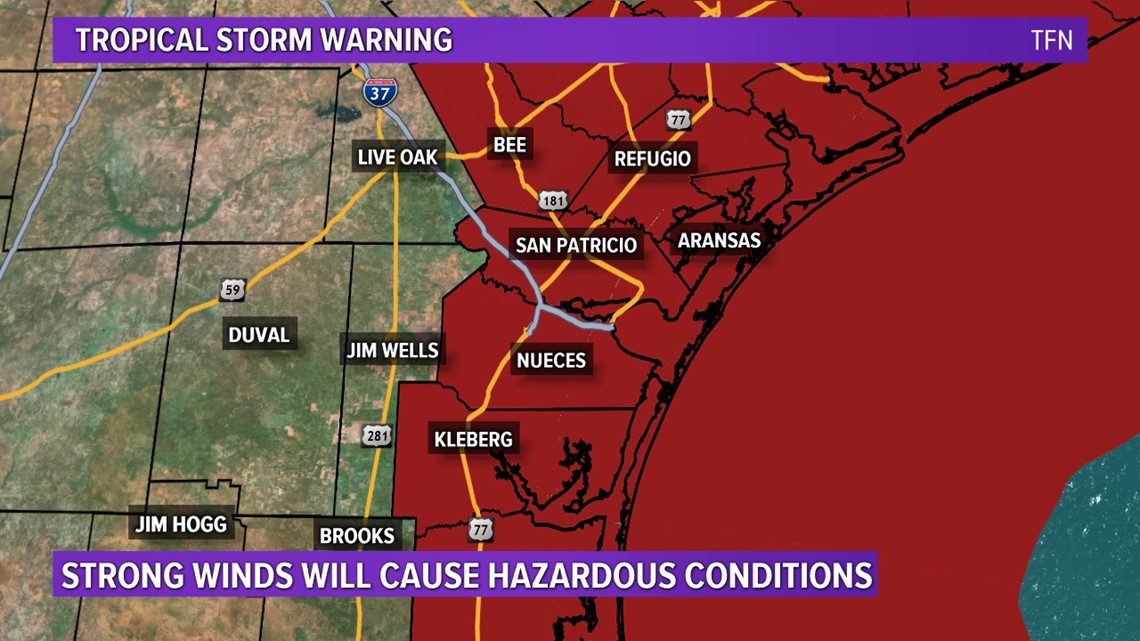
UPDATE: 4 p.m.
- Tropical Depression #8 is expected to make landfall as 60 mph Tropical Storm Hanna near Corpus Christi early Saturday afternoon.

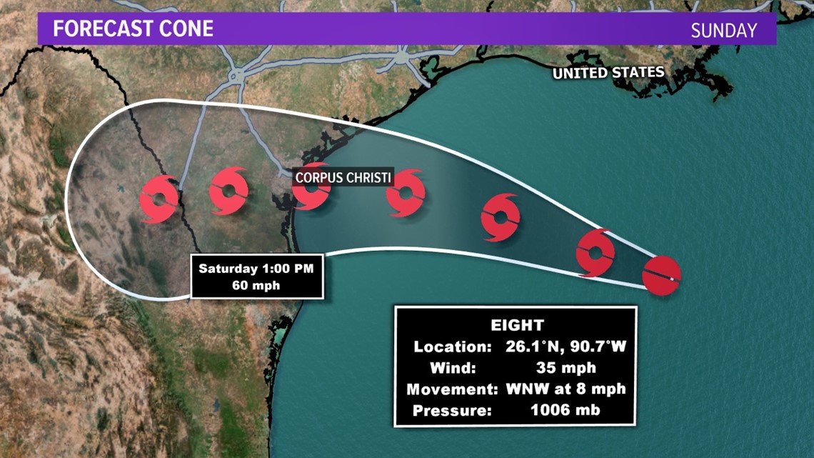
UPDATE: 3:35 p.m.
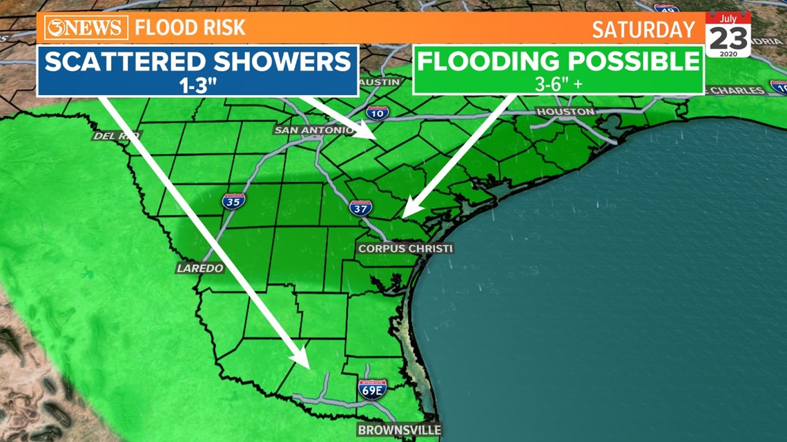
- Given the current forecast on T.D. 8, the most likely areas to experience flooding (especially Saturday) will be in SE Texas, down to the Coastal Bend and extending westward into Laredo. The area marked in dark green has 3-6" chances of rain with isolated higher totals possible. This is from Friday to Monday - the most active day, Saturday, as the storm moves in.

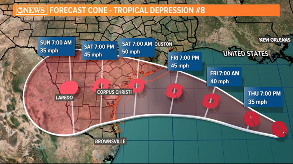
Latest update brings Tropical Depression #8 to Tropical Storm strength (Hanna), Friday. Landfall near San Antonio Bay/Copano Bay Saturday morning or early afternoon with 50 mph winds; gusts up to 60-65 mph, into Mexico as a tropical depression on Sunday. Flooding rains still the primary hazard.


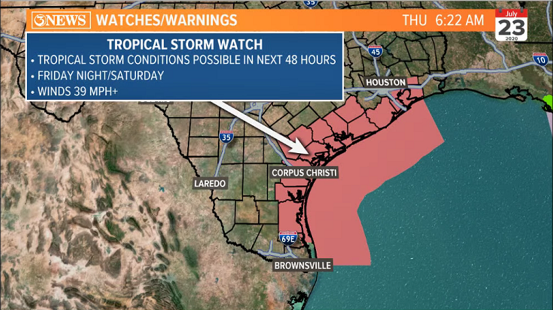
Tropical Storm Watches will go into effect Friday night and into Saturday as this system approaches. While winds are forecast to be strong, it is not to the point of boarding up yet. Loose lawn items need to be secured or brought in prior to Saturday. A trend that I've noted over the last 24 hours is forecast models increasing wind speeds little by little. The latest run of models brings in moderate tropical storm force conditions as this storm makes landfall Saturday.

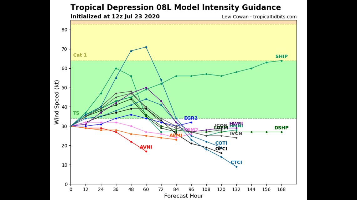
Tropical downpours, dropping heavy rains, leading to flooding remains the primary threat. Widespread 4-6" expected across the Coastal Bend. Isolated higher totals. This will likely lead to ponding/standing water or impassable roads on Saturday. Travel is discouraged, Saturday.

