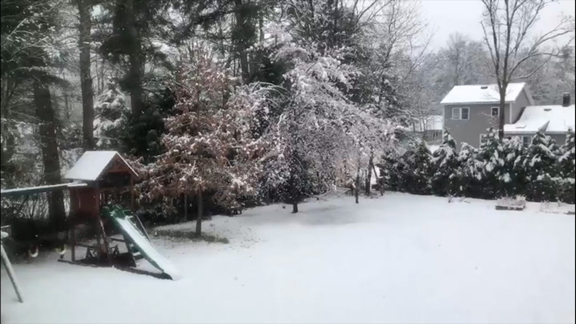
Americans across a large portion of the Northeast are bracing for an unusually late-season blast of Arctic air courtesy of the polar vortex this weekend. Adding to the frigid conditions will be accumulating snowfall, another rarity for some places across the region this time of year.
Freeze watches and warnings have been issued in many places. And cities from Atlanta to Detroit to New York to Boston will be colder than parts of Alaska this weekend. Pittsburgh, Detroit, Washington, D.C., and Buffalo will challenge low-temperature records.
Meanwhile, Fairbanks, Alaska, will approach 80 degrees Fahrenheit on Mother's Day, which is about 20 degrees above normal. Farther south in The Last Frontier, it will be cooler in Anchorage over the weekend, but with temperatures in the low 60s, highs will still be about 4-5 degrees above average -- and higher than some places in the Northeast.
Not only will the frosty weather be more conducive to social distancing across the region than last week's pattern was, accumulating snowfall will stretch across a swath as far south as West Virginia and extend through interior portions of the Northeast up into New England, where some places could pick up a foot of snow or more.

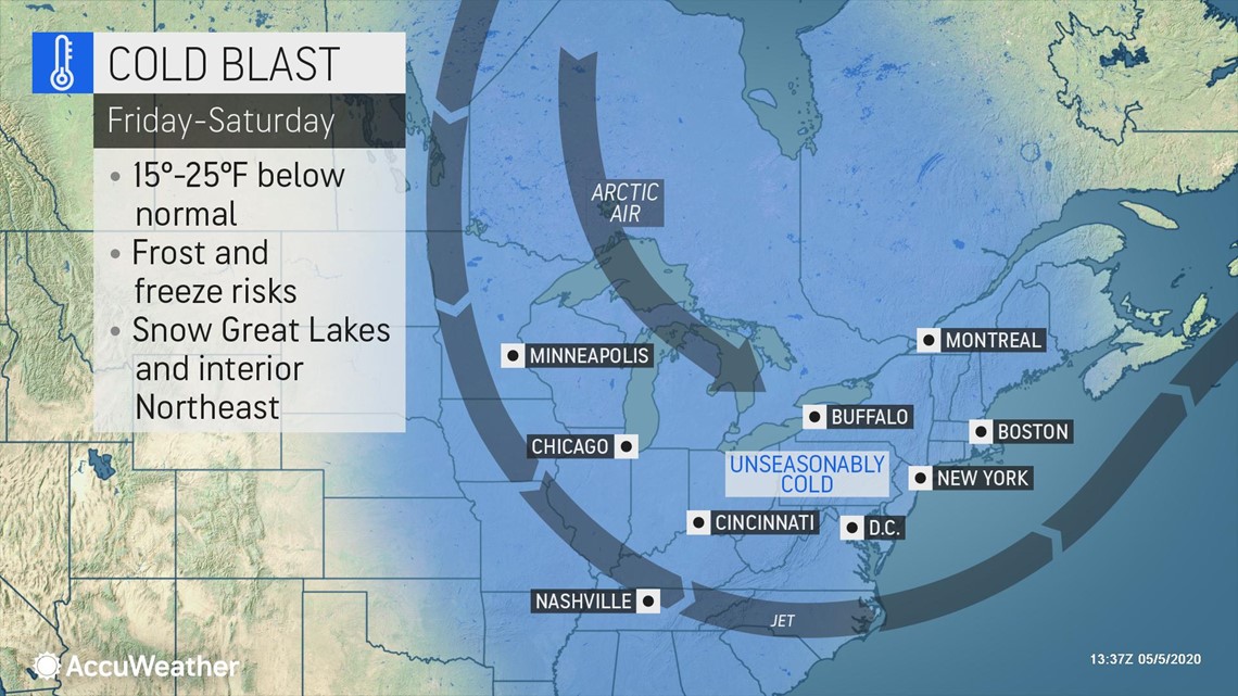
"A lobe of the polar vortex will spin southward and loop around the Great Lakes and northeastern United States into next week before shifting farther northwest over Canada toward the middle of May," Paul Pastelok, AccuWeather's top long-range forecaster, explained.
As the jet stream plunges across the eastern U.S., allowing the unusually cold weather to press southward, it is bulging northward in the West. An oppressive heat wave is affecting L.A., Phoenix and Las Vegas as warmth builds across the Pacific Northwest and up toward Alaska.
"What a pattern across the United States! Look at that big jet stream across the eastern U.S. Meanwhile, in the West, it's totally opposite, polar opposite, where we're looking at record warmth ... It will be warmer in Alaska than it will be in Atlanta, Georgia. That's something," AccuWeather Chief On-Air Meteorologist Bernie Rayno said.
Way too cold for May in the East
Even though strong May sunshine will work to negate some of the chill by day, where thick clouds linger and rain or snow falls, daytime temperatures can hover in the 30s to lower 40s F, which is about 20-30 degrees below normal in the Midwest and Northeast.


However, despite the warm May sun shining, some locations can still rival record low maximum temperatures as the air coming in is from the Arctic. Washington, D.C., will challenge a record low maximum temperature of 52 on Saturday -- a mark that has stood since 1877. The 143-year-old record at stake in the nation's capital is a testament to the magnitude of the frigid air coming into the region.
"Other places where low maximum temperature records could be set on Saturday include Hartford, Connecticut, Boston and Mount Pocono, Pennsylvania, to name a few," AccuWeather Meteorologist Jesse Ferrell said. The old low maximum temperature records are 45 in 1972, 45 in 1966 and 41 in 1947, respectively.
Where the wind is active and during cloudy intervals, AccuWeather RealFeel® Temperatures can hover 10-20 degrees below the actual temperature during the daytime. It may feel like the temperature is in the 20s and 30s at times even during the midday hours.

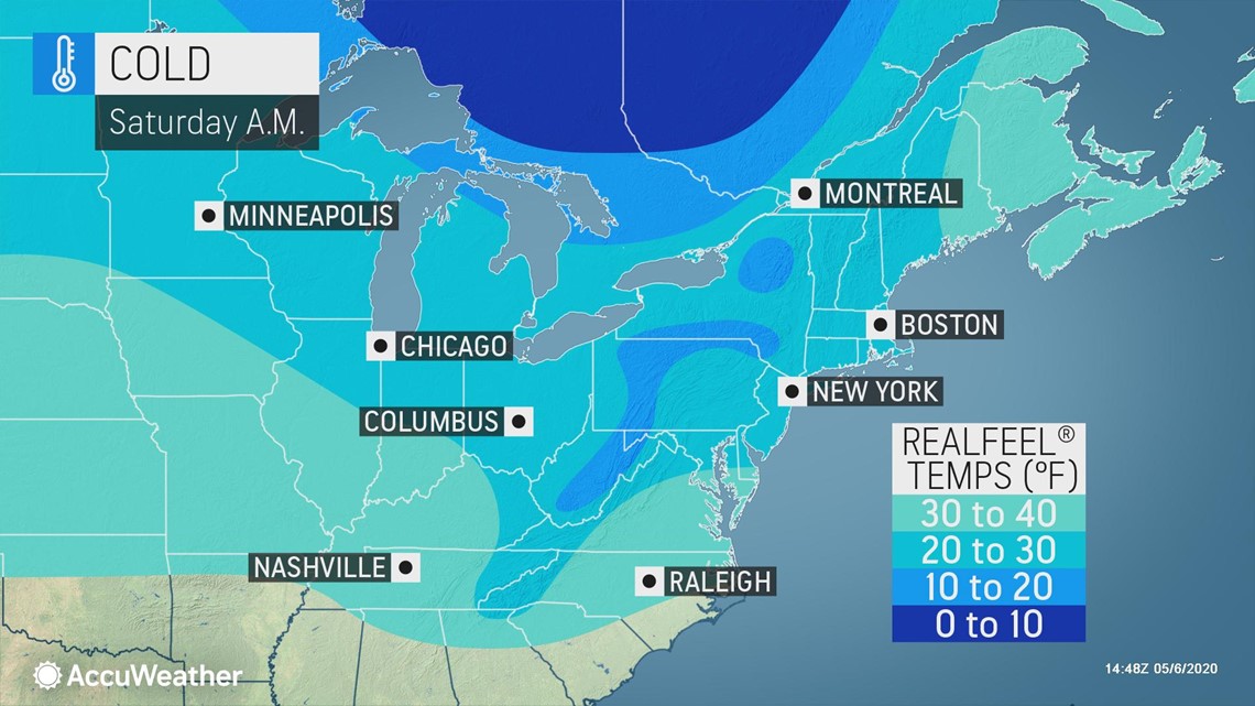
Actual nighttime temperatures will dip into the 20s and lower 30s and will challenge record low levels for the date in portions of the Great Lakes, Ohio and Tennessee valleys and the central and northern Appalachians. The coldest nights will occur where the sky becomes clear for several hours and the wind drops off to allow the coldest air to collect near the ground.

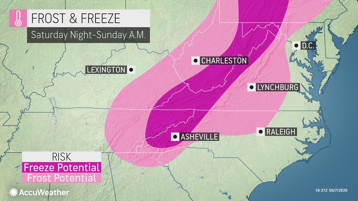
AccuWeather meteorologists recommend covering your warm weather plants or bring potted plants indoors at night until the pattern eases up later next week.
"If a hard freeze or heavy frost occurs in portions of the Ohio Valley, central Appalachians and mid-Atlantic region, where buds have broken out, significant damage could occur to fruit trees, vineyards and berry farms," said AccuWeather Senior Meteorologist Randy Adkins.
The surge in temperatures this past weekend may have been just enough to bring some vegetation out of dormancy across the northern tier. In a few extreme cases, temperatures could dip as low as the upper teens in the coldest spots across the northern locations this weekend.
Agricultural interests may need to implement every means possible, such as wind machines, smudge posts and sprinkler systems, to raise the temperature a few degrees around crops.
"Old-timers in the region typically don't plant their tomatoes, peppers and other warm-season plants until around Memorial Day weekend to reduce the chance of frost or freeze damage," said AccuWeather Senior Meteorologist Dave Dombek, adding that this is sound advice for this year in particular.
Farther south, record lows, short of frosty levels, in the 40s and 50s will be challenged on one or more nights from central Texas to the Carolina coast.
Not just one round of snow
Perhaps the wildest part of the weather pattern will be the rounds of snow coming for some locations. Even though snow has fallen and accumulated in May in the past, those events are generally very small in areal coverage and are usually a "one and done" type of phenomenon.

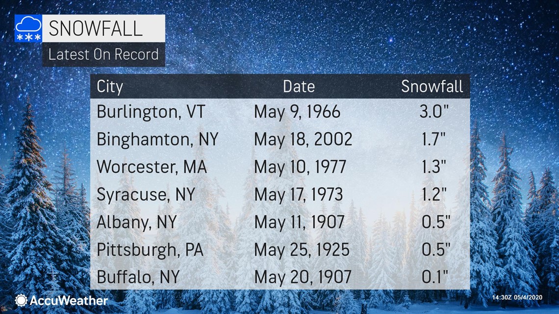
"A storm will spread a swath of snow from the central Appalachians to interior southern and central New England from Friday to early Saturday," Rayno said.

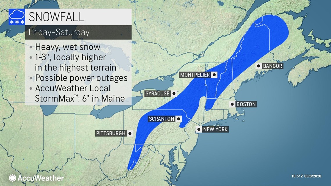
Some snow is forecast to fall and accumulate from this storm from the mountains of West Virginia to eastern Maine. Anywhere from a few snowflakes mixed with rain to steady snow and a slushy accumulation on grassy areas can occur in the valleys and lower elevations in this corridor.

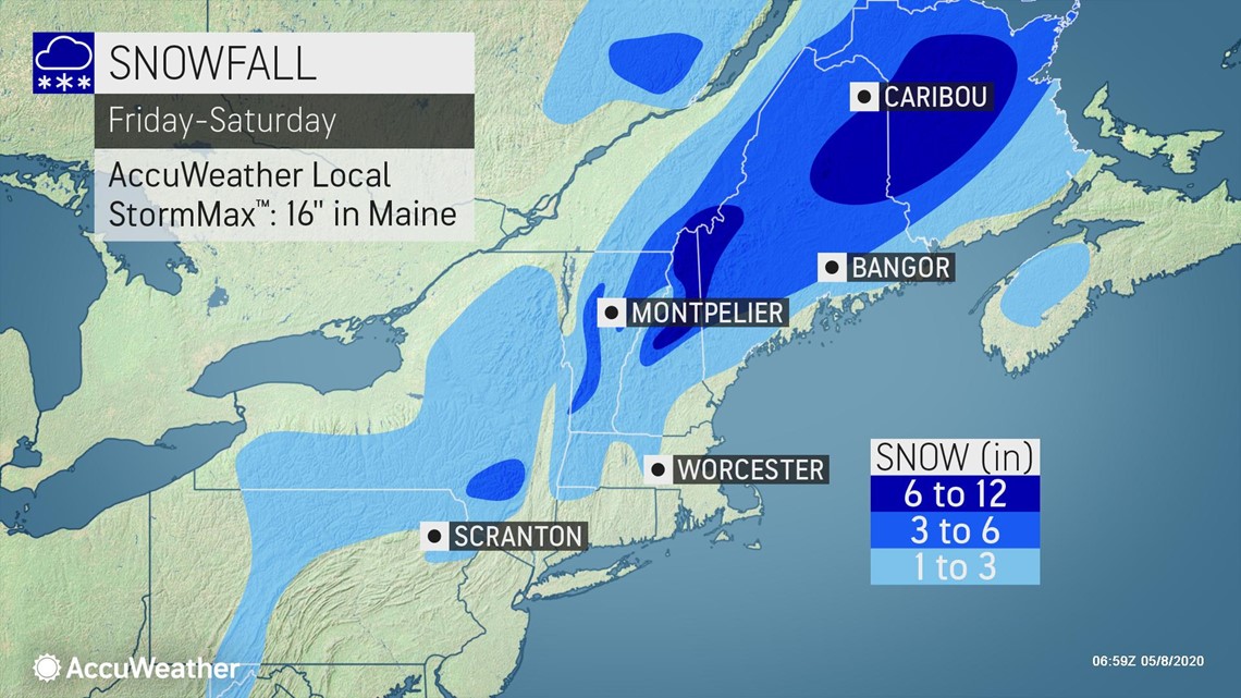
The exact track of the storm and where the heaviest band of precipitation occurs will be critical factors for total accumulation amounts. It must snow at quite a heavy rate to accumulate this late in the season.
However, at elevations above 1,500 feet, a few inches of snow could pile up on grassy areas and roads over the ridges could become slushy and slippery for a time.
Even heavier snow totals, along with a higher risk for power outages and travel disruptions are anticipated in northern New England. In the higher elevations of northern New Hampshire and Maine, there can be an AccuWeather Local StormMax™️ of 16 inches.
AccuWeather meteorologists are monitoring another storm with its sights set on the Upper Midwest on Sunday and the Northeast on Monday.
Even though the coldest air may pivot away ahead of the storm, the air may still be cold enough to allow snow or a mixture of rain and wet snow from the upper part of the Mississippi Valley and lower Great Lakes region to the central Appalachians and southern New England.
Lake-effect snow in May?
Following the storm-related snow to end this week, another unusual event will occur -- lake-effect snow spanning Friday night to Saturday. Usually during May, the water is too cold and the air not cold enough for lake-effect snowfall.

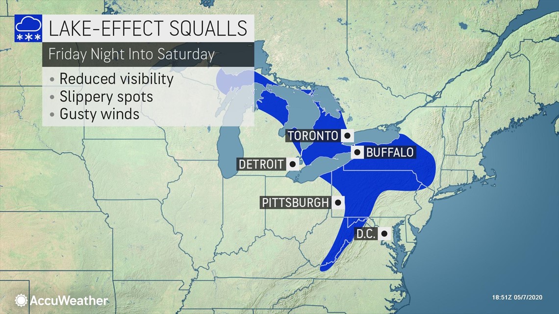
In this case, only 0.2 of a percent of the Great Lakes is covered by ice and the air is going to be cold enough to trigger bands of snow. Where strips of lake-effect snow and snow showers persist, a coating to a couple of inches can accumulate on grassy surfaces from portions of Michigan to northeastern Ohio, northwestern Pennsylvania and western New York state.

