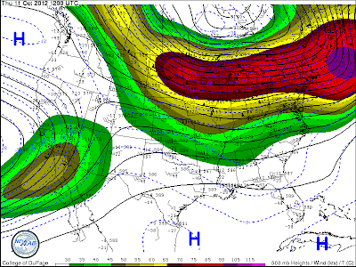
Most of the time, weather forecasters focus on the placement of atmospheric troughs, which bring colder weather, and ridges, which warm us up. But what about the weather in-between? When there aren't any large synoptic (large-scale) troughs or ridges in our atmosphere, it is called a zonal flow. ?
From the College of DuPage Weather Site
?The above picture depicts a fairly zonal flow in the continental USA. The lines of constant height at 500mb on this map are almost straight across, from Utah all the way to the DC Metro and beyond. Notice how the wind barbs are oriented almost straight across, too. A zonal pattern allows weather systems to move almost straight across the country, in an easterly direction.
If you study weather patterns, you'll start to notice that areas of precipitation move relatively quickly through a zonal flow. The antithesis of this pattern is the meridional flow, pictured below.?
From the College of DuPage Weather Site
?Can you see the difference? Ahhhhh, just kidding. Of course you can! There's a giant U-shapedtrough covering the entire USA east of the Rocky Mountains.A meridional pattern, or amplified flow, has much more movement in a north-south direction than a zonal pattern. This aids in slowing down the east-west movement of any weather system. That's why deep troughs often bring heavy rain, and conversely,amplified ridges lead to dry stretches of weather. In a zonal flow, it's much more common for storm systems to move through quickly.
The zonal pattern also prevents weather extremes. An amplified flow allows cold air to spill southward into a trough, and warm air to surge northward into a ridge. But, the straight across movement of a zonal flow prevents those strong temperature contrasts from happening. So, temperatures tend to be close to their seasonal average when a zonal pattern is in place. If you're interested in weather forecasting, I encourage you to look at the maps on a regular basis, and try to spot the patterns on your own!


